Credit NASA Goddard Space Flight Center Image by Reto Stöckli (land surface, shallow water, clouds). Enhancements by Robert Simmon (ocean color, compositing, 3D globes, animation). Data and technical support: MODIS Land Group; MODIS Science Data Support Team; MODIS Atmosphere Group; MODIS Ocean Group Additional data: USGS EROS Data Center (topography); USGS Terrestrial Remote Sensing Flagstaff Field Center (Antarctica); Defense Meteorological Satellite Program (city lights).
This spectacular “blue marble” image is the most detailed true-color image of the entire Earth to date. Using a collection of satellite-based observations, scientists and visualizers stitched together months of observations of the land surface, oceans, sea ice, and clouds into a seamless, true-color mosaic of every square kilometer (.386 square mile) of our planet. These images are freely available to educators, scientists, museums, and the public. This record includes preview images and links to full resolution versions up to 21,600 pixels across.
Much of the information contained in this image came from a single remote-sensing device-NASA’s Moderate Resolution Imaging Spectroradiometer, or MODIS. Flying over 700 km above the Earth onboard the Terra satellite, MODIS provides an integrated tool for observing a variety of terrestrial, oceanic, and atmospheric features of the Earth. The land and coastal ocean portions of these images are based on surface observations collected from June through September 2001 and combined, or composited, every eight days to compensate for clouds that might block the sensor’s view of the surface on any single day. Two different types of ocean data were used in these images: shallow water true color data, and global ocean color (or chlorophyll) data. Topographic shading is based on the GTOPO 30 elevation dataset compiled by the U.S. Geological Survey’s EROS Data Center. MODIS observations of polar sea ice were combined with observations of Antarctica made by the National Oceanic and Atmospheric Administration’s AVHRR sensor—the Advanced Very High Resolution Radiometer. The cloud image is a composite of two days of imagery collected in visible light wavelengths and a third day of thermal infra-red imagery over the poles. Global city lights, derived from 9 months of observations from the Defense Meteorological Satellite Program, are superimposed on a darkened land surface map.

Metadata
		Sensor Terra/MODIS
		Visualization Date 2002-02-08
			.	All Sensors MODIS
			.	All Satellites Terra MODIS
	.	All Categories Collections Blue Marble Blue Marble 2002
Credit NASA Goddard Space Flight Center Image by Reto Stöckli…
Environmental Stewardship

Celebrating Earth Day

Earth Day was first observed on April 22, 1970 as the brainchild of former Sen. Gaylord Nelson (D-WI). One of the leading proponents of environmentalism and conservation at the time, Sen. Nelson envisioned Earth Day as an “environmental teach-in” that would generate popular support for an environmental agenda. Modeled on the anti-war teach-ins of the gloomy Vietnam era, over 20 million people participated in the inaugural Earth Day. Ever since, Earth Day has been a largely somber event sounding the alarm on impending environmental doom.

Instead of merely generating awareness of the environmental problems we face, Earth Day should be a celebration of the wonderful achievements the U.S. has made in improving air and water quality. Although there will always be areas for improvement, overall environmental quality has improved significantly. Technological improvements, wealth generation and sensible regulations have led to some of the cleanest air and water in the world.

Sadly, this story goes largely untold, yet it is probably one of the greatest success stories of our modern age.

emissions

As we wrote about in our 2012 publication Economy Derailed, traditional pollutants have been on the decline for decades and continue to go down. According to the U.S. Environmental Protection Agency (EPA), between 1980 and 2013, gross domestic product (GDP), population and energy consumption increased by 145, 39 and 25 percent, respectively. During that same period of time, emissions of the six criteria pollutants (e.g., carbon monoxide, ozone, lead, nitrogen oxide, sulfur dioxide and particulate matter) dropped by an average of 62 percent.

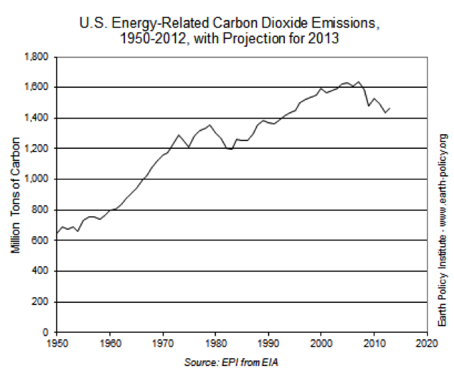
Energy-related emissions of heat-trapping carbon dioxide have also been on a downward trajectory since 2005 and are nearing mid-1990s levels. Most have pointed to the recent fracking boom and utilities opting to generate more electricity from cheap natural as the primary driver for this trend.
co2-emissions

There will always be room for continued improvement, but these environmental achievements should be roundly celebrated. Instead of resigning ourselves toward a future of inevitable environmental degradation, we should be optimistically encouraged by the fact that technological improvements and wealth generation will continue to provide us with some of the cleanest air and water in the world.


In Depth: Environmental Stewardship

Listen to any news broadcast, read any press release from an environmental advocacy group or simply watch the U.S. Environmental Protection Agency (EPA) propose new regulation after new regulation, and it would be nearly impossible to not come away concerned or even fearful of imminent environmental disaster. It should come…

+ Environmental Stewardship In Depth